

The Everglade Outlaw Coast
Smuggling, Smoking, and Satellites!

For nearly a century, the Ten Thousand Islands have served as Florida’s untamed backdoor. This area at the end of the everglades is a labyrinth of mangrove tunnels and oyster bars, where in true Florida style, folks are on island time and the only perfectly enforced law was the tide. In the 1920s, this watery wilderness became a haven for rum-runners who used the shallow, shifting channels to evade heavy Federal cutters, turning the quiet fishing villages of Chokoloskee and Everglades City into covert ports of call for Caribbean liquor. Not just anyone could navigate these dense waters, it took locals who grew up on the water to outrun the law.
Each generation passed the geographic knowledge down to their kids, everyone fished and the waterways were where one played, worked, and commuted. After prohibition ended the skills forged in that era were handed down, teenagers often got a boat on their 16th birthday not a car. As you would imagine being able to navigate the pitch-black backcountry without a chart in a speedboat found a new purpose in the 1970s.
In the 1970’s commercial fishing was restricted and the local economy cratered, the sons and grandsons of those early pioneers became “saltwater cowboys,” swapping mullet for marijuana, pills, and powder. Under the cover of the mangrove canopy, they transformed these islands into one of the primary entry points for the “Square Grouper” era, hauling millions of pounds of contraband through a landscape that swallowed outsiders whole. When you take a look at the area historically and today you can see why.
I thought how complex the area really was, you had all the rivers leading in land themselves lined with canals, the mangroves provided overhead cover to hide from helicopters if you knew which ones your boat would fit through. Thousands of islands and sandbars that change constantly or even appear and disappear over time. So, I started mapping it out.
The Smuggler’s Highway
To the uninitiated, the map of the Ten Thousand Islands is a chaotic splatter of green and blue, but to the smugglers, it was a precise network of arterial highways.
The Barron River served as the brazen front door, the region’s dredged commercial heart, where shrimp boats laden with bales would dock under the guise of a night’s catch.
The Chatham River offered a deeper, darker route. A historic channel echoing with the legacy of Edgar Watson, known as the Everglades’, most notorious outlaw. The local legendary villain you hear about at a bar from an old timer.
Edgar Watson grew up murdering and escaping justice, after killing his cousin he fled west where he promptly killed another outlaw, Belle Starr. You can’t make up bar fodder this good. He returned to Florida, bought land, hired workers and they just kind of disappeared. After enough mysterious disappearances, Watson finally succumbed to mob justice at or around the Smallwood Store on Chokoloskee Island where he was riddled by bullets, dragged to Rabbit key and buried in a shallow grave.
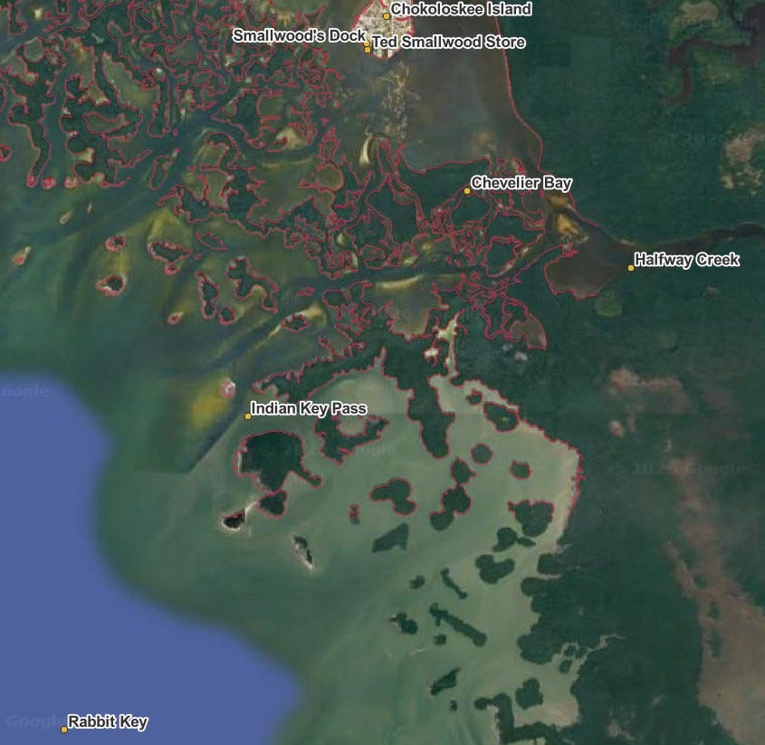
Rabbit Key in relation to The Smallwood Store.
The Chatham River provided direct, deep-water access to the hidden interiors of the Glades. Smugglers used the high banks of the Chatham (rare in the mangroves) to offload onto higher ground: the shell mounds left by the Calusa, a thousand years earlier. Ah I need to map that out too..
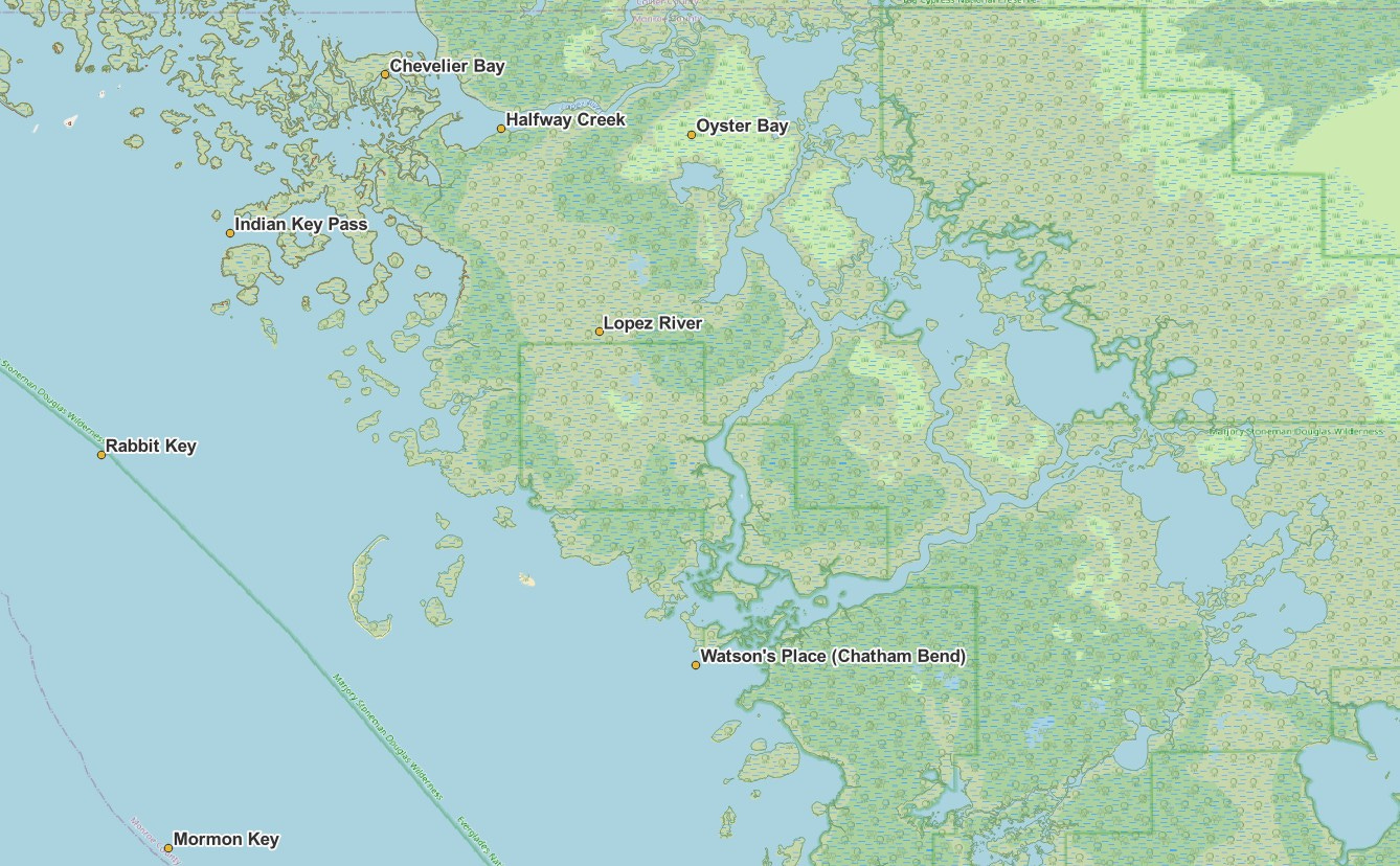
The Lopez River was the winding “back alley” — named for the family who settled it — connecting the inland bays to the Gulf. Smaller skiffs slipped through unnoticed, avoiding rough seas and patrols alike.
And then there was the Wilderness Waterway: a now a celebrated 99-mile paddling trail, but originally the “Inside Route.” It allowed traffickers to move cargo from the Cape Romano shoals all the way to Flamingo without ever exposing themselves to the open Gulf or the Coast Guard’s gaze.
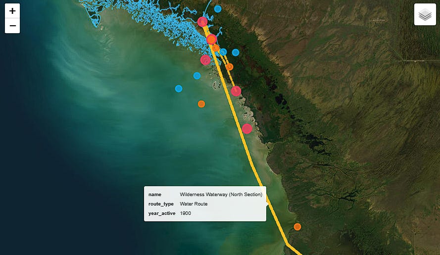
Satellite view of the Ten Thousand Islands showing smuggling routes (gold dashed lines), historical sites (colored markers), and the 1978 NOAA coastline survey (cyan). Built with Folium + PostGIS.
Points of Interest
The map includes 20 documented historical sites across the region, color-coded by significance:
Everglades City (est. 1923) — The hub. Where Operation Everglades (1983-84) physically blockaded CR-29 to trap the smuggling network.
Chokoloskee Island — The shell mound island where Edgar Watson was shot by his neighbors in 1910. Later a staging ground for the Square Grouper era.
Watson Place, Chatham River — Watson’s remote plantation. High banks made it ideal for offloading.
Smallwood Store — The frontier trading post, now a museum, that served as the commercial nerve center of the islands.
Flamingo — The southern terminus of the Wilderness Waterway and Everglades National Park.
The 1978 Coastline
The NOAA coastline survey of 1978 captured this landscape at a critical moment — just before the biggest drug busts of the era. The dataset contains 5,689 individual features classified as SHORELINE and ALONGSHORE FEATURE, rendered from the original NAD83 projection into web-ready WGS84 coordinates via PostGIS.
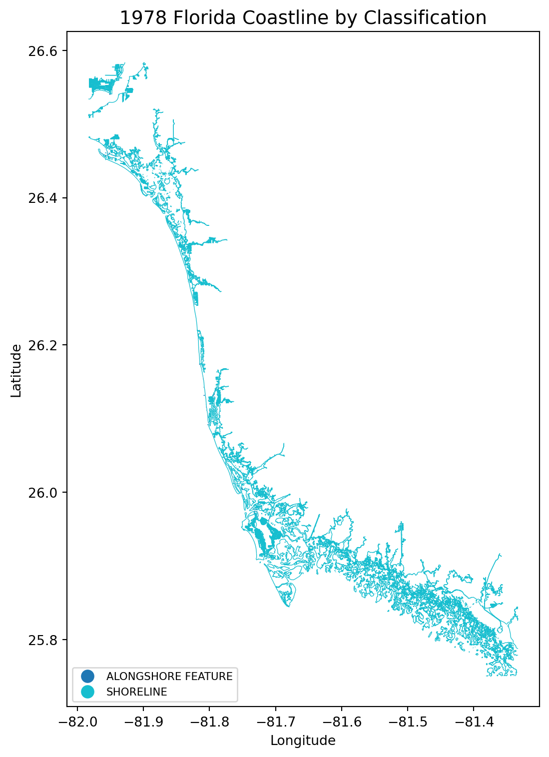
1978 Florida Coastline by Classification — 5,689 NOAA features showing the intricate mangrove labyrinth of the Ten Thousand Islands. Data: PostGIS/PostgreSQL.
Interactive Map
This is part of an ongoing GIS story mapping project. If you’re interested in historical geography, narrative cartography, or just good smuggling stories — subscribe for more. I will be adding more detailed satellite images of the mangroves of the area as well as periodically updating the interactive map. Here is the link to the interactive version of this article:
Source Material
Peter Matthiessen, Killing Mister Watson
Charlton W. Tebeau, Man in the Everglades
Totch Brown, Totch: A Life in the Everglades
William G. Truesdell, A Guide to the Wilderness Waterway
“Calusa to Campbell” — NPS Historic Resource Study
US District Court, Middle District of Florida, “Operation Everglades” Case Archives (1983-84)
Everglades City, Florida’s Bootlegging Capital (video documentary)